Advances in artificial intelligence and satellite imagery have helped scientists create the clearest map yet of human activity at sea, revealing hidden fishing vessels, oil rigs and offshore wind farms.
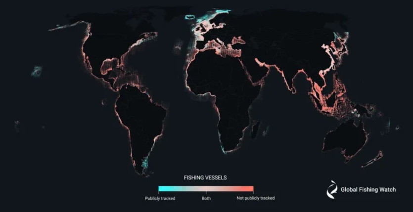
Maps published in the journal Nature by the non-profit organization Global Fishing Watch with the support of Google, show 75% of commercial fishing and 30% of transport and energy vessels avoiding public tracking. Researchers say these white spots in the exploitation of water resources could hamper global efforts to conserve and protect the world’s oceans.
According to the Kunming-Montreal Global Program for the Conservation of Biodiversity, adopted last year, governments committed to protect 30% of the Earth’s land and water by 2023.
“The question is, which 30% should we protect? You can’t have a discussion without knowing where the fishing is actually going and where the oil rigs are,” said David Krudsma, co-author of the paper and director of research and innovation at Global Fishing Watch.
Until now, Global Fishing Watch and other organizations have relied primarily on the Maritime Automatic Identification System (AIS) to see what’s going on in the oceans. The system tracks vessels using radio signals, but has serious limitations as this option can easily be turned off or travel to areas where the signal is weak.
To fill in the gaps, Krudsma and his colleagues analyzed about 2,000 terabytes of data from the ESA Sentinel-1 satellite constellation.. Instead of traditional optical images similar to photographs, satellites use advanced radar instruments to observe the Earth’s surface. The radar can penetrate clouds and “see” in the dark – and it was it that was able to find marine activity that passed AIS.
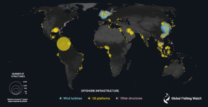
To process such a huge amount of data scientists created three AI models that classified each detected vessel, estimated its size, and sorted it by different types of activity. Scientists monitored about 15% of the world’s oceans, where 75% of industrial activity takes place, looking at both ship traffic and the development of fixed offshore structures such as oil rigs and wind turbines between 2017 and 2021.
While fishing activity declined at the start of the COVID-19 pandemic in 2020, according to public tracking systems, satellites detected heavy vessel traffic in areas that “previously showed little or no activity” — particularly around South and Southeast Asia, as well as the northern and western coasts of Africa.
As for marine energy, according to the study, by the end of 2020, wind turbines will exceed the number of oil installations. The following year, they accounted for 48% of all ocean infrastructure, while oil accounted for 38%. Not all of the offshore wind energy boom took place near the coasts of Northern Europe and China.
At the same time, over the 5 years of the study, the number of oil structures increased by 16%.. In 2021, offshore oil development generated five times more vessel traffic than offshore wind.
Source: The Verge